

During my last months in village, I decided to do a World Map Project for which members of the community get together and paint a world map on a wall. The idea for the World Map Project got started back in 1988 by a Peace Corps volunteer in the Dominican Republic who came with the idea as a means of getting students interested in world geography. The idea caught on with other Peace Corps volunteers as it's a fun project which instills pride and accomplishment in the participants, encourages cooperative problem solving, and builds community. I thought it'd be a great way to bond with my community members and leave a sort of memory of my presence before I go.
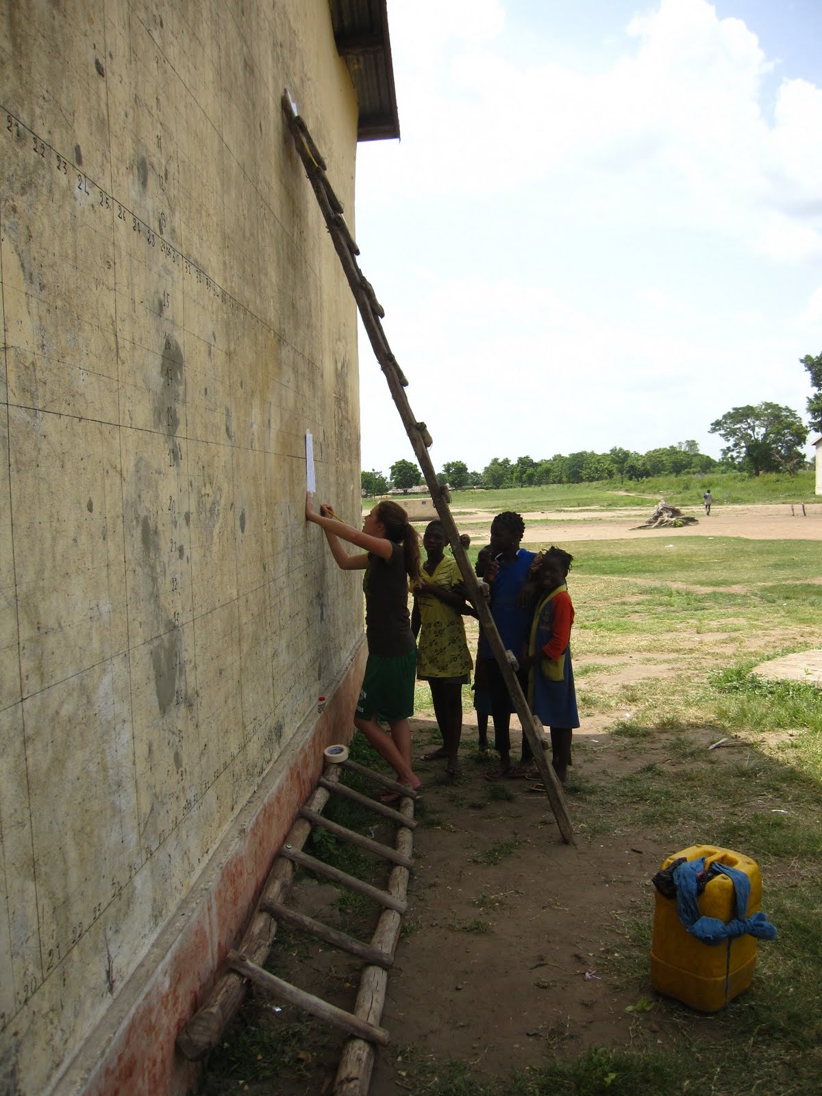
The goal is to create an accurate hand-drawn map of the world. To do so, you first draw a big grid on your background surface. Then you transfer information block-by-block from map section sheets onto this proportionately larger grid. One of the hardest parts was making the grid (which was approximately 5x3 meters) straight and even considering we only had a meter stick to create the entire thing. In the early days of making the grid, I stopped by a local carpenter's workshop one day in the hopes of finding a longer ruler or measuring tape. There was an older man, who I often see sitting outside the shop with the apprentices, sitting there who greeted me by name. I assumed he was the head carpenter. I asked him if he had a long ruler, but he didn't seem to understand what I was asking for, so I broke out the World Map Project manual and showed him the mini picture of the map on the grid, explaining that we were going to recreate it on the elementary school wall. He looked at me with wide eyes and said "That is way too small to draw on the wall!" After I clarified that I was going to enlarge it, I tried asking again for a large ruler to use to do so, but he still didn't seem to understand what I was asking for. So I said, "OK - say for example I come to you today and ask for the measurements of this wall [pointing to the wall next to us]. How would you go about measuring this wall?" He looked pensively at the wall, stroked his chin and hmmmed, saying "Ah yes - I understand now". After a couple nods he turned to me and said "Ok - and when would you need those measurements by?" After 15 minutes of a conversation that went nowhere, I found out that the man wasn't even a carpenter. In the end, I ended up making do with the yellow meter stick I already had.
Although it requires a lot of steps, schoolkids from all over the world succeed in drawing the map themselves. To select the kids who would help me, I went around to classes in the local middle school and invited those students who were interested in the idea of the project to participate in a preliminary "training" of this process of recreating images using the grid method. I was initially worried that the students would find the project too time-consuming and tedious, but I was pleasantly surprised by how intrinsically motivated they were. Overall, about 10 kids helped consistently, showing up on time and, at the end of every day, anxiously asking what time we'd start working again the next day. It was so heartwarming to see how excited they were to create this map! I was careful to check their work and often had to make some corrections, but overall the kids did a great job. I could tell they were encouraged by any positive praise I gave them. One day when we were painting, I was working on the right side of the map with some kids and another kid was standing on a bench on the left side, painting the countries that were green. I heard a noise and saw that he had slipped on the bench and had caught himself, but he was gawking at the wall. A little suspicious, I got off my ladder and went to go see what the problem was. When I got over there, I realized that when he'd slipped, he'd spilled his paint, and an enormous blotch of green was covering the Pacific Ocean. He was looking at his toes and I could tell he felt bad about it, so I made as little a deal as possible out of it, even though I was sighing in my head. Good thing I had extra blue.
I spent a total of approximately 80 hours over the course of May working on the map. I'd work in the mornings starting at dawn, sweating like crazy under the sun which blazed on the eastward-facing wall. In the evenings, I'd work more productively in the shade with the kids who'd help after they got out of their classes. Kids and adults alike would love to gather and sit on the grass to watch us as we worked. One day, as I was working on the Northwestern Territories, I noticed the director of the school walk into the building with a man who was carrying a big tube attached to a plastic gallon bottle of liquid. Minutes later he came out and said that they were going to be spraying to get rid of the pests who were making noise in the roof and suggested that I might want to stop working for a while. Not wanting to lose any time, I said that I'd continue working and if it bothered me, I'd stop. Not long afterwards, I started smelling a raunchy stench emanating from the holes in the roof and then heard a high pitch screeching accompanied by clattering coming from the inside. The kids who were sitting on the grass were getting all worked up and excited, and they started standing up and looking for sticks in anticipation of whatever was going to be escaping from the roof. Thinking twice, I scrambled down the ladder and in the nick of time too because just then HUNDREDS of little bats started streaming out from the small holes between the wall and roof and filling the sky. I felt like I was in a Hitchcock film. I fled for cover but the kids screamed with delight and whipped and flailed their sticks in the sky trying to knock down as many bats as possible. Once I was at a safe distance and didn't feel I was at risk for getting knocked in the head by a diving bat, I found the whole scene absolutely hysterical. Too bad I didn't have my camera that day.
Many Peace Corps volunteers often look for external funding to produce the World Map, but due to time constraints (since I was to be leaving in less than 3 months at the time of planning this), I decided to go ahead and fund the project out of my own pocket. My PCV neighbor, Michelle, graciously contributed as well - both financially and manually, biking down from her village for a couple days to help out with the drawing and painting. It was fun to have this to do as a collaborative project with her before leaving as well. In total, the map cost us about 60 USD to produce. Reasonable, we thought, since it should now ideally last a few years and should contribute greatly to the global education of the young students in my village.
Even before the map was finished, I already started seeing the ways in which the map is challenging my villagers' views of the world. When I originally started the project, people had trouble with the concept that it was a map of the world instead of just Africa. As hard as it is to believe, many people in my village did not understand that there are other continents in the world besides Africa! You have to remember - there are few, if any, books available for students who live in the remote villages like my own. Most students in my village had never seen a map of the world drawn all on one page. The school wall on which I painted the map was right next to a path that many farmers follow in going to and from fields, so at dusk I often attracted a fairly large crowd of farmers who would stop and stare and ask questions with their hoes propped over their shoulders. The biggest attraction was little Togo, which "is so small!", they'd exclaim. But they loved jumping up and pointing to it; the little yellow-painted country was already covered in fingerprints before the map was even finished. However, the villagers were even more blown away when I'd point out little islands and explain that they too were countries. "Someone lives THERE?" they'd say. In painting other African countries, I took advantage of the focus on the countries to explain historical events such as the Rwandan genocide and the civil wars in Sudan. My villagers were astounded that such big countries could still have such serious problems. "So Togo is actually doing well!" they'd exclaim in understanding. "Bigger isn't always better after all" they'd reassure themselves. I'd always smile to myself too when I'd be working and I'd overhear schoolkids rehearsing the historical facts they knew about the countries in the world, now using the map as a visual reference. Many adults would come up to me and thank me, saying how grateful they were for this huge service that I was providing in improving the knowledge of the kids and adults in the community. The map was truly an appreciated project.
The day we finished, I could see the kids who had helped practically bursting with pride as we wrote their names on the wall as I'd promised them. A big crowd gathered to admire the map and lingered even after I'd gone home. It's such a good feeling to finish a project that you know is appreciated by your village and will benefit them in some way. The craziest thing to me was that during the entire month, I had prayed that the rain would hold off and not erase or delay my work before I'd finished it. There were a couple close calls, but no huge rainstorms ever actually came during the time I was working on it. I was so relieved. The day that the rain finally came was the night I finished. What luck!
And that was my last big project in village! I am done with my work and am preparing to leave soon!
Enjoy the pictures below~
Making the Grid:


Drawing the countries:


 (Finished the drawing!)
Painting:


Writing in the country names:

Finished!


MORE PICTURES FROM MARCH - MAY:


 me with the current and old middle school directors


(above and below) Me doing a sensibilization on how to make lotion that contains insect repellant made from Neem tree leaves.


Mango season! How schoolkids use sticks to bring the mangoes down to their level

Dancing during Cultural Week at school


(above and below) Culinary contest during cultural week; the director and I were the judges

 me with the current and old middle school directors
Planting Moringa with middle school students


Model Teacher Conference I organized, led by one of my former Peace Corps Trainers, Ismael


6 comments:
Fantastic idea! I'm going to tell my son James about this, see if he'd like to do something similar in his village. What a great idea!
Kristina,
We have truly enjoyed your photos and writings for the last two years. We will be visiting Grant in Togo in two weeks and perhaps we will meet. Even in your days of frustration, the passion, joy and dedication to your PC service was obvious. Best wishes to your future.
Wow, great job you're doing there. Very nice place and photos. Greetings from Oman.
la carte -- formidable! I painted a hippo on the side of a dive shop on Phi Phi Island (Thailand) once, and it took all my concentration -- I can't even begin to imagine the whole world . . .
Jan Braithwaite
Post a Comment